2010-03-11

School report and generic server app


Right now we are working on the project report that we are supposed to hand in to our teachers the next week. We will probably write a short summary of it and publish it in English as well.

I've recieved quite a lots of requests from people that want's to use the serverapp (PenemuNXTExplorerServer) to use with their own mapping robots. Of course is all code open source so it's free for everyone to download, change and use it for free. But I've understood that our project structure, and how to get the app to compile isn't that simple. The reason is that we use something called "linked source". It's an easy way to share the same code between two projects. We can't link the projects in this case, because we need to specify that the PC code shall compile with the leJOS pc classes and the NXT code shall compile with the leJOS client classes.

I will write more about how this works soon.

I will also try to make a more generic map application that shall be really simple to customize to fit for your map data. The code is already based on "modules" and "plugins" so it shouldn't be that hard to make this.

More updates will be posted during the weekend.

/Peter F

2010-01-03

PenemuNXT Explorer Server Preview and Screencast

You can now download and try a preview of the PC app.

First watch the screencast that presents all the features.


What do you think?

2009-12-14

Updates

Some updates
  • Twitter: You can now also find us at Twitter for short but more frequent updates. http://twitter.com/PenemuNXT
  • Refreshed design: For the YouTube page (http://www.youtube.com/PenemuNXT) and this blog (http://penemunxt.blogspot.com/).
  • New short description: "A SLAM (Simultaneous Localization and Mapping) implementation using LEGO Mindstorms NXT and leJOS (Java)."
  • Reorganized Google Code Page: More info at http://code.google.com/p/penemunxt/.
  • Map orientation: Rotate the map. This is supposed to rotate the map automatically by using data from the Compass sensor. But we have not implemented this yet, for now you have to rotate it manually.
  • New map processors:
    • Visualize clear area: Area where there probably are no objects are now displayed as white.
    • Background grid: A grid with squares that represents 10x10 cm so that it is easier to calculate lengths.
  • Performance optimization
  • Export rendered map: You can export a rendered map as PNG or JPEG to share with your friends ;)
Some images

This is the environment that is visualized in the maps below.


Export as PNG or JPEG:


2009-12-09

Map Preview

I have separated the visualization of the map to a separate control.
Because of this it's really easy to reuse it in different ways.
I've done this in three places for now.


Map processors preview
Preview what the map will look like if you activate the map processors that you select.


Map timeline preview
If you hover the mouse over the timeline you will see a thumbnail with a preview of the map at that frame.


Map preview
According to me this is the coolest thing. When you are about to open a map from a file you will see a preview of it as you select one.


The next thing to do is to separate the timeline as a separate control so that it is as easy to reuse as the map.

2009-12-06

Map processors

The big news of today is map processors!!
That's a new way we implement how the map is painted/processed.
The idea is that you want to be able to add new ways to improve the map easily.
What I did was to setup the interface IMapProcessor and basically it has some properties for color, name and description and a method to process the data.
You can find the processors we have at the moment here.
They all implement the IMapProcessor interface.

There are two main types of processors, SimpleData and CalculatedData.
* SimpleData is processors that basically just paint dots. For example when the robot drive. It dosn't do any improvements to it.
* CalculatedData is processors that combines different data to calculate different stuff, for example where walls and objects are.

You add all the processors you want to an instance of MapProcessors and call this every time you want to paint the map.

This is how it might look when you configure it:
ArrayList defaultProcessors = new ArrayList();

mapProcessorCurrentPos = new MapCurrentPos(Color.GREEN, 10, true);
mapProcessorHotspots = new MapHotspots(15, false);
mapProcessorFindLines = new MapFindLines(true);

defaultProcessors.add(mapProcessorCurrentPos);
defaultProcessors.add(mapProcessorHotspots);
defaultProcessors.add(mapProcessorFindLines);

mapProcessors = new MapProcessors(defaultProcessors);


This is the new admin view for them.


You can easily change size..:

..and colors:


I also made a change so that when you select a row in the dataview the timeline will jump to that frame (and if you drag/play the timeline, the dataview will jump to that frame):


Hopefully we will release a compiled version of the apps soon so you easily can download them and test them by yourself!

/Peter F

Show at school

We showed the robot and what it can do at our school.
I think most people liked it though some might have been confused by all the dots :)
Here are some pictures from that day.


2009-11-12

Latest improvements

We've done some improvements to the project, I'll list them below:
  • Renaming of the projects
    • PenemuNXTExplorer
    • PenemuNXTExplorerClient
    • PenemuNXTExplorerServer

    • PenemuNXTFramework
    • PenemuNXTFrameworkClient
    • PenemuNXTFrameworkServer
  • Rearranged UI
    • New colors, logo, menu, margins...
  • Timeline
    • We can now "play" saved data and go to specific positions in it
  • Save and open
    • Save and open maps as files (*.penemunxtmap and *.penemunxtmapxml)
  • Filters
    • A function to filter out irrelevant data and draw lines between the correct data
  • View raw data
    • A table shows the raw data (sensor values from the robot) we base the map on
  • Hotspots
    • Shows places on the map where we have accurate data with big red circles, less accurate with small green circles
Screenshots


/Peter F

2009-11-10

Improvements and show at the school

We've made loads of improvements the last days. The reason is that tomorrow we will show the robot live @ our school for the first time. It's only a demo of the prototype.

Screenshots


I will write a more detailed description of the improvements tomorrow.

If you want to see us demo the robot you should be @ Berzeliusskolan tomorrow (11/11) @ 18.00.

/Peter F

2009-11-05

Save and Open map data

I've now implemented a save and open functionality. This enables us to save the raw data (positions, headings, distance etc.) as a XML file that we later on can open and import into the application.
This is a useful function in many ways. We can now work on the server functionality even though we don't have the NXT with us (for example when we are in school). We just use saved data and let the serverapp process this instead of data retrieved by Bluetooth. As it is for now all the data is imported at once but I will implement a emulating functionality. This will add the saved data with the same time delays as it was recorded. This will enable us to play back what happened. I think I will implement this by adding one more connection type. Instead of choosing between USB and Bluetooth you will be given the choice File and instead of passing the name of the NXT you pass a filepath to the file containing raw values.

One of our goals is also to publish the data to a webserver so that a client can connect and see the map being created in real time. The export function is one step towards that.

This is how the new control panel looks like:

Intelligent A.I.

So far we have put all the work towards making a prototype that can do the basic goal we have, and we have more or less succeeded. However the AI that controls the robot has so far been pretty stupid to say the least. Simply put it has gone in a straight line until it gets too close to an obstacle and then turned. Now we have started working on something that can manage a little more than that.

The strategy we've planned for the robot is the following:

  • Start by either scanning around or simply drive forward until it approaches an obstacle.
  • Follow the outline of that obstacle until the robot reaches a position it has already visited.
  • If the first obstacle was an object the robot had driven around then let the robot simply drive in another direction and find a new obstacle. If it was the circumference of the area ( such as the walls of a room) the robot will begin scanning the remaining unexplored area until it's sure it has found all objects.
  • Eventually we will hopefully implement something which uses the map it has created, such as pathfinding or cover the area in an efficient way (something that could be of use for e.g. automated vacuum cleaners).
This is still a very rough draft and will most likely be subject to significant changes, but it's a start none the less.

Right now we're on the second point: we're working on an algorithm which will follow the curves and turns of a wall or the side of an object. The first iteration will consist of the behavior we already have (turn left when too close to something), a behavior to align the robot parallel to the wall and a behavior to detect when the wall turns away from the robot. If done right this should be enough to work in the vast majority of all cases.

2009-10-18

Improved UI

Today I improved the UI that controls the robot and that displays the map.
It now looks like:


It has support to zoom in the map by scrolling the mousewheel or by draging the slider on the left panel. If you want to pan the map you just have to drag it.
It's quite the same as Google Maps.

The left panel has also been more structured and now you can easily choose between USB/Bluetooth and change what NXT to connect to.

I also refactored the code so that it looks a little bit more structured :)

/Peter F

2009-10-17

A working prototype!

We are happy to announce that we now have a working prototype. Our robot can scan its surroundings and return data to a server which in turn visualizes it.


This was the try ever in creating a real map, and the results aren't very impressive. Fortunately we've already managed to improve it quite a bit from that, although there is still very much left to be done.


A simple AI controls the robot to reach around to be able to scan. Because of bugs in the current release of leJOS we have been unable to use the Compass Sensor and the as a consequence the accuracy has been suffering. This is something we hope will improve fairly soon.

Also, the AI is so far very simple, but thanks to the behavior based programming we're using, it will be relatively simple to continue working on what we have and expanding it until we some day will have an algorithm which can tackle most problems with reasonable accuracy.


The bar to the left is a control bar which shows some data from the robot and also has options for what you want to be painted. The labels are pretty self-evident, save for "Bumps" which is simply when a behavior has taken over from the default forward in a straight line. Blue indicates that the ultrasonic scanner in front has detected an obstacle and red that the robot has crashed into something with its bumper.

The arena of today was a (roughly) 3 by 1.5 meter rectangle, and you can clearly see the shape of the area, although it's far from perfect. Considering how early in the project we are we're quite satisfied. In fact, we're following our schedule pretty nicely. This far was about what we planned to be by the end of next week.

Now we will continue to work on mainly the AI, to give it an intelligent algorithm instead of the almost random we have now. Naturally we will continue to improve the other aspects as well, so stay tuned!

/Josef and Peter

2009-10-15

New Robot

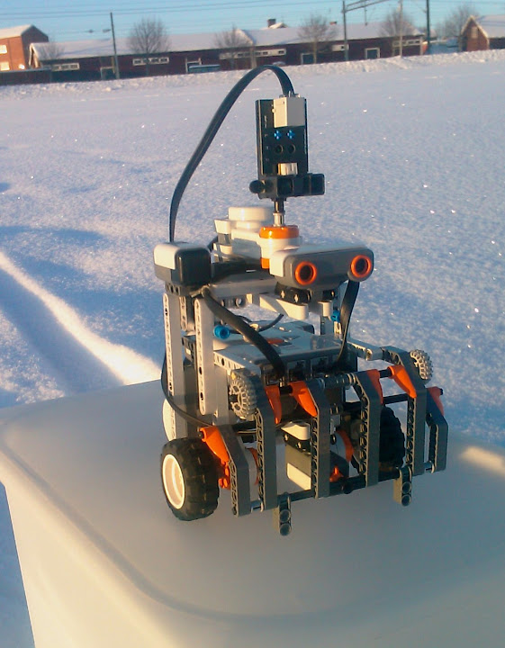
As promised we have constructed a new robot that probably will be the one, or at least very similar to the final product. It is based on the Explorer robot from Nxtprograms.


Our requirements for the physical units was that it has to be able to rotate around its own axis (a requirement for the leJOS navigation classes) and that the IR sensor has to have a 360 degree field of view. A bonus with this model compared to others we have considered is that the IR sensor rotates directly on a motor. In earlier versions we had to convert between the rotation of the motor and the sensor, something we don't have to worry about anymore.


Aside from changing the sensor on top to our IR sensor, we have added a compass sensor and fitted the Ultrasonic sensor in front instead. We also slightly modified the top motor and sensor so that its rotational axis is between the wheels, something that will facilitate calculating the position of obstacles.

Today we have also done several tests to determine how accurate the navigation classes are, and the results are somewhat disappointing. For some reason navigation with the help of the compass sensor is actually less accurate than a simple tacho navigator that only uses the rotation of the wheels to navigate. Also, bugs with both classes severely limits the amount of methods we can use and still maintain a reasonable accuracy. For now we have settled on using Forward(), Backward() and Rotate(), which is accurate enough for our needs. Hopefully we (or leJOS, which is still in beta after all) will solve some of the problems and we won't limited to these forever.

/Josef and Peter

2009-10-07

Communication framework and a broken NXT

When I first bought the NXT the sound from its speakers were not good at all, at first I thought it was supposed to be like that, it's just Lego and probably a cheap speaker. Anyhow just a couple of days later there were no sound from it at all so for a couple of weeks ago I sent it in to be repaired/replaced and now the new one has arrived :) So that's why we haven't been able to do and write especially much the last time.

PenemuNXTFramework 0.1

Anyhow what I have done while the NXT was gone is that I've written a communication framework that's supposed to be a middle layer between the existing communication classes in leJOS and the programmer. It's based at some interfaces that you must implement and then it will handle a lot of stuff for you.

Some key features are:
Queue: Let you to setup a queue of set of data to send. This allows you to send data when the NXT has time, maybe there is much to do at the moment.
Priority: Give priority to a set of data, this means that it will be sent first of all items in the queue and it will be processed first at the receiver. Good to use for shutdown commands.
Consistent: The syntax and classes used is exactly the same ones at the NXT as at the PC.
Choose type: When you setup the communication you specify if to use USB or bluetooth. You only specify it once and you don't have to change anything else.

This is how the base part might look:
// Setup data factories
// They produce empty instances of the data objects
NXTCommunicationDataFactories DataFactories = new NXTCommunicationDataFactories(
new ServerMessageDataFactory(), new TiltSensorDataFactory());

// Setup ..
NXTCommunication NXTC = new NXTCommunication(true, DataFactories,
new NXTDataStreamConnection());

// .. and start the communication
NXTC.ConnectAndStartAll(NXTConnectionModes.USB);


// Setup a data processor
// It will be given the incoming queue of data and handle it
ServerMessageDataProcessor SMDP = new ServerMessageDataProcessor(NXTC, DataFactories);
SMDP.start();

//Add some data to the send queue
NXTC.sendData(new TiltSensorData(TS.getXTilt(), TS.getYTilt(), TS.getZTilt()))


A data factory might look like this:
public class SensorDataFactory implements INXTCommunicationDataFactory {
@Override
public SensorData getEmptyInstance() {
return new SensorData(NXTCommunicationData.MAIN_STATUS_NORMAL,
NXTCommunicationData.DATA_STATUS_EMPTY);
}

@Override
public INXTCommunicationData getEmptyIsShuttingDownInstance() {
return new SensorData(NXTCommunicationData.MAIN_STATUS_SHUTTING_DOWN,
NXTCommunicationData.DATA_STATUS_ONLY_STATUS);
}

@Override
public INXTCommunicationData getEmptyShutDownInstance() {
return new SensorData(NXTCommunicationData.MAIN_STATUS_SHUT_DOWN,
NXTCommunicationData.DATA_STATUS_ONLY_STATUS);
}
}


And part of a data processor like this:
@Override
public void ProcessItem(INXTCommunicationData dataItem,
NXTCommunication NXTComm) {
SensorData SensorDataItem = (SensorData) dataItem;

Acceleration.add(new AccelerationValues(SensorDataItem.getAccX(),
SensorDataItem.getAccY(), SensorDataItem.getAccZ()));
}


So it's not finished yet but soon I hope. Anyhow this will make things much easier for us when we want to share data to the computer and back.

Right now we are rebuilding the robot and hopefully we will upload some pictures later this evening.
We are basing the new model on the Explorer from NXTPrograms.com, it's much more stable the our previous construction.

/Peter Forss

2009-09-06

New release of leJOS firmware

I've now updated the robot and the computers to leJOS 0.85.
According to http://lejos.sourceforge.net/ the changes are:
  • better support and documentation for MAC OS X, including the Fantom USB driver
  • a Netbeans plugin
  • improved JVM speed and many more amazing improvements by Andy
  • support for the new LEGO color sensor in the NXT 2.0 set
  • now supports the instanceof keyword
  • detection of rechargeable batteries and improved battery indicator
  • nanosecond timers and improved timer support with the Delay class.
  • % operation on floats and doubles
  • Class, including the isAssignableFrom(Class cls) method
  • display of LCD screen in ConsoleViewer
  • major speed and accuracy improvements to the Math class from Sven
  • platform independent lejos.robotics packages
  • new navigation proposal (work in progress) that is platform independent, supports more vehicles, has better localization support, and new concepts of pose controllers and path finders
  • preliminary support for probabilistic robotics, including general purpose KalmanFilter class using matrix algebra
  • reworking of the Monte Carlo Localization classes
  • limited java.awt and java.awt.geom classes
Sounds good :)

/Peter F

2009-09-05

Old memories

Before NXT there was RIS with RCX and I have two of those.
A couple of years ago me and a friend built two robots that were able to find eachother, dock and then exchange a ball.

One of them has a lamp and the other one has a lightsensor. The "child" scans 360° to find the lightest point and then head for that direction. On his way he is doing small adjustment to always head for the lightest point, in other words the "mother".

Here is a video showing the docking process:


It's a little bit sad that I've lost the latest version of the program that contains the "ball exchanging" part (and I haven't got the time to rewrite it) so the video dosn't show that.

This isn't actually part of PenemuNXT, just fun to show the world :)

/Peter Forss

AI and communication

While we still don't have anything new to show you right now, though that doesn't mean that we're slacking. We've started working on two different things that together should enable us to create a working prototype for our mapping robot.

I (Josef) am working on an AI for the robot so it can navigate through the room while scanning. I tried to create my own navigation class that would calculate the position of the robot based only on the rotation of the wheels, but for some reason it's not working. The algorithm to calculate the angle its facing seems to be working, but only certain values for some reason. Seems like a rounding error somewhere, but I don't know where.


public double getRobotangle(){
robotnewangle = robotangle - (Math.toRadians(CS.getDegreesCartesian()));
robotangle = (Math.toRadians(CS.getDegreesCartesian()));

leftwheelangle = ((Math.toRadians(Motor.A.getTachoCount())) - leftwheeloldangle);
rightwheelangle = ((Math.toRadians(Motor.B.getTachoCount())) - rightwheeloldangle);

leftdist = ((wheeldiameter*Math.PI)*leftwheelangle/(2*Math.PI));
rightdist = ((wheeldiameter*Math.PI)*rightwheelangle/(2*Math.PI));

return robotangle;
}


The algorithm to calculate it's position doesn't seem to work at all, even if I use values from the compass sensor. For some reason it never returns any data.


public Point getRobotpos() {
float x, y, hypotenuse;

hypotenuse = (float)(Math.sqrt((2*Math.pow((getRobotAverageDist()/robotnewangle),2))
-((2*Math.pow((getRobotAverageDist()/robotnewangle),2))*Math.cos(robotnewangle))));

x = (float)(robotpos.x + (Math.cos(getRobotAverageangle()*hypotenuse)));
y = (float)(robotpos.y + (Math.sin(getRobotAverageangle()*hypotenuse)));

robotpos.x = x;
robotpos.y = y;

return robotpos;
}


Feel free to check them both out on our Google Code site and come with tips if you have. Right now the code is a bit unstructured however. The algorithm to calculate the angle based on the rotation of the wheels is a comment right now in favor for a similar method that uses the compass sensor instead.

When my own class didn't work I was forced (for the time being anyway) to use the navigation class in leJOS, which unfortunately limits me to use only the methods provided by the class to navigate the robot. I'd rather be able to manipulate the motors at will, for example to be able to follow a wall easily.

I'm using behavior programming for my work, a really smart way of creating AI's, since it's so easy implementing, editing or removing different parts of it. I recommend reading the leJOS tutorial about it if you're interested.

Peter is working to improve our communication, which as you could see in our movie works already, but could be made a lot smoother and more structured. The idea of the new communication class is that you add data that you want to send to a queue. The class will then process one item at a time and send it over either USB or Bluetooth (depending on what you want to use). The receiver will add each received item to a list and you may then process them whenever you want. There is one client (NXT) part and one server (PC) part in this.

Hopefully, when we're done with these things, or at least got something that works, we can combine it with the scanning algorithm we already have and with small tweaks to the Graphic Interface a crude prototype that should be able to move around and scan a room, and in real-time paint it up on a computer screen.

/Josef
2009-09-01

Description document

Today we published two PDF-documents describing our project PenemuNXT more in detail. One in Swedish and one in English.

You can download them from here:

PenemuNXT - Swedish
PenemuNXT - English

2009-08-26

Logo

Today we created a simple logo for the project.

Landscape


Download as:
PNG
EPS
SVG

Portrait


Download as:
PNG
EPS
SVG


What do you think?

2009-08-21

Improved scanner

Except that we had a lot of problems with the USB communication today (which turned out to be due to a driver error) we improved our scanner a lot. Today we used te OpticalDistanceSensor instead of the UltrasonicSensor and it turned out that OpticalDistanceSensor had much better accuracy when you get the distance in an angle. It seems to be like the optical solution is much better then the ultrasonic one.

Anyhow, this is what the test looked like:


Comparison

Comparison between the old sensor and the new one:

OLD (Ultrasonic)


NEW (Optical)


As you can see the new one looks a lot more like the environment the scanner is standing in. The odd lines in th corners are there because there is space between our boxes and the sensor recognizes them. Though there is still more to improve.

We also tested the new Accelerometer/Tiltsensor.


No big test yet, just printing out all info on the display to se that it works.

Enough for today.
/Peter and Josef